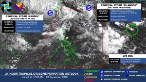
Four tropical cyclone-like vortices (TCLVs) are likely to form until next week, one of which may intensify into a tropical cyclone, according to the Philippine Atmospheric, Geophysical and Astronomical Services Administration (PAGASA).
In a tropical cyclone threat potential (TCLV) released Thursday, tropical storms Korvanh, formerly locally known as Pilandok, and Saudel, formerly Obet, will continue to persist and be monitored from today until Sept. 9, called week 1.
Both tropical cyclones, which are currently affecting the southwest monsoon, are already outside the Philippines Area of Responsibility (PAR).
During the same period, TCLV 1 may emerge over the northeastern part of PAR, with a low chance of developing into a tropical cyclone, PAGASA said.
By week 2, which covers Sept. 10 to 16, another three TCLVs are likely to develop within the PAGASA monitoring domain (PMD), one of which has a chance of developing into a tropical cyclone.
TCLV 2 is likely to occur over the eastern portion of the tropical cyclone advisory domain (TCAD) and could enter the northeastern portion of PAR.
PAGASA said that the weather system has a low to moderate chance of developing into a tropical cyclone.
Meanwhile, TCLV 3 will form over the western boundary of the PMD and TCLV 4 may emerge over the Northeastern portion of the PMD. Both TCLVs have a low chance of storm development.
“Therefore, the TC-threat potential remains active over week 1 and likely during week-2,” PAGASA said.
The bureau also said that it will closely monitor any changes in the forecast pattern and issue updates if necessary. — Edg Adrian A. Eva